As the directions I have found online for this hike were often misguided, I found some online and corrected the mistakes. However, I have since forgotten where I borrowed some of the text from, so if you find it, please let me know so that I can credit the source. Also, if you find these directions in error, please email me at abraham dot olson at gmail.com.
Driving Directions
HWY 26 to just before Zigzag Ranger Station. Left (north) on Lolo Pass for 4.25 miles. Take right fork (Muddy Fork Rd) for about 1 mile and bear left onto Road 1828 (if you get to Fred McNeil Campground, you’ve gone to far). Continue 2 miles to another fork and bear right. After another 3.7 miles, the road forks again (and there is a wider gravel area to your left), take the right, unpaved fork. 1.5 miles more up that road is the Top Spur Trail Head N.785.

Hike Directions
Begin at Top Spur Trailhead cutoff trail #765. A steeper climb through the woods for 0.5 miles where it intersects with Pacific Crest Trail #2000. Take a right and go a bit farther to where 5 trails intersect. The trail that is second from the left (i.e. one to the left of the Ramona Falls Trail) is the one you want. This trail leads around Bald Mountain, and provides a great view of Mt Hood and the Sandy Glacier on a clear day. At some point after the two viewpoints, the trail re-enters the woods. Look carefully for a trail leading up over a hill to your left. You will exit your current trail and take that one to reconnect with the main trail to McNeil Point, Timberline Trail #600–on which you will take a right.

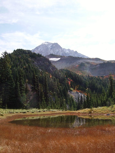
Continuing for quite some time, you will catch views of Mt Hood and, if it’s clear, Mt Adams, Mt St. Helens and Mt. Rainier. The trail will eventually bring you to two lakes, one on the right and one on the left. The desired trail is just before the second lake, and goes up into the woods to your right. However, make sure to go to the second lake and enjoy the view of Hood. It may be the best on the mountain.
Continuing upwards, the trees begin to shorten, and eventually you will make it to a series of valleys with creeks. The trail to McNeil used to go up one of the valleys, but is closed now to restore the meadow-land. Thus, you must continue on until you reach a sign that points the way (right) to McNeil Point. Follow this up, and–after a bit of a climb–you will reach a small shelter on the ridge that leads up to McNeil Point. About another 800 feet up that ridge–a steep climb–is McNeil Point, from which you can survey all of the surrounding area on a clear day. It also provides a great, up-close view of Mt. Hood.
Note: on your return trip, you can skip going around Bald Mountain and just follow the Timberline Trail to the intersection of the 5 trails.
Last Updated: August 25th, 2007